
.png?width=644&name=Brazil%20Permanent%20Offer%20Blocks%20LP%20SM%20(Land).png)
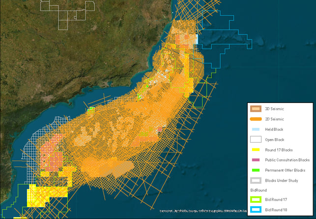
With over 452,000 kilometers in 2D multi-client data and approximately 72,500 square kilometers in 3D multi-client data in Brazil, TGS seismic data covers every basin, sector, and Permanent Round policy block offshore Brazil. This library of modern, long-offset data, available in both time (PSTM) and depth (PSDM), comprises the largest and most comprehensive high-quality dataset offshore Brazil.
Over the last 30 years, the vast “petroliferous” margins of Brazil have consistently provided some of the largest discoveries in the world. State-of-the-art 2D seismic data is the pathfinder for exploration and production companies, not only to develop the best resources of the pre-salt play of the Santos and Campos Basins, but also to unleash the high potential of the underexplored Aptian rift/syn-rift play and deep water clastic and carbonate plays of the Ceará and Potiguar Basins of the Northern Equatorial Margin.
For a full overview of the Permanent Offer Bid Round Acreage, take a look at our story map.
Ceará and Potiguar Basins
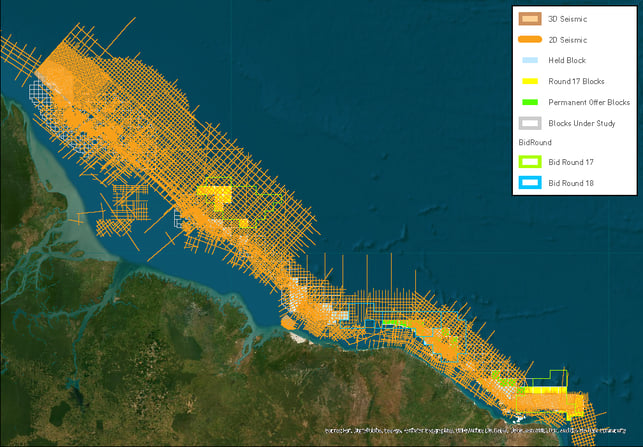
In addition to over 10,000 km of legacy data, over 17,200 km of modern, long offset data was acquired over the Ceará and Potiguar Basins in 2011- 2012 to chase both slope and deepwater post drift plays, and the thick syn-rift sections. Both basins have geological exploration successes, indicating a working petroleum system and potential deep water reservoirs. Play risk is removed by the Pecém and other wells of the Ceará Basin and the Pitu well of the Potiguar Basin. This 2D data was reprocessed in 2017, creating a superb regional dataset to assess the value of the 17th Licensing Round (2020/2021) and Permanent Round blocks.
Chosen datasets can be scaled for the maturity of the evaluation: a regional grid of 2D data for basin characterization, play potential recognition, and the presence of reservoir, seal, and source rocks.
Sergipe and Alagoas Basins
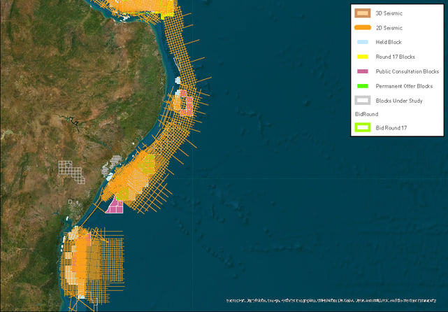
TGS offers 16,300 km of long offset 2D data in the Sergipe Basin. This data, and the 8,000 km of legacy data on the Sergipe shelf, underpin the plays into deeper water adjacent to the Petrobras blocks. This data has been depth processed to suit the complex structural geology of this basin and can be considered as the main hydrocarbon generating sub-basin.
The TGS Regional 2D seismic grid identifies the active petroleum system and multiple leads in the Sergipe-Alagoas Basin. Although several blocks have been purchased in recent Bid Rounds, including the First Permanent Round offering, other highly prospective blocks remain in upcoming Permanent Round being offered in 2020.
Santos and Campos Basins
TGS holds the most extensive 2D long offset dataset (over 53,000 km) in the Santos Campos basin and recently completed 17,500 square kilometers of 3D seismic in the area, enjoying an exclusive position over much of the Permanent Round acreage. This highly coveted area holds blocks surrounded by major operators. Our supporting data in the area allow the structural highs in open acreage to be identified and mapped.
The TGS Regional 2D seismic grid identifies the structural trend of the Base Salt beneath the blocks offered in the Second Permanent Round. Though the majors have snapped superb blocks in past Bid Rounds 15 and 16 those structures surround and extend into the 3 blocks offered.