New Data Reveals Exploration Opportunities Offshore Norway

There’s never been a better time to explore the Norwegian Atlantic Margin.

02f_AMN_Lysing_profile

Norway is well-positioned to assure Europe's security well into the next decade. The Norwegian Petroleum Directorate estimates that 24 billion barrels of oil equivalent are still to be discovered in their offshore territory. Energy security and higher prices are expected to encourage explorers to re-evaluate forgotten gas-prone basins such as the Møre and Vøring basins in the Norwegian Sea Atlantic Margin. Proximity to the EU market and the ability to support new infrastructure makes any discovery valuable, and the chance of making significant finds is considerable. 


In some cases, exploration had previously been hampered by a lack of geological understanding in the region where where few wells have been drilled geoscientists previously did not have access to sharp, well-defined subsurface images of drilling targets nor any facts or knowledge about the intra- and sub-basalt sedimentology.


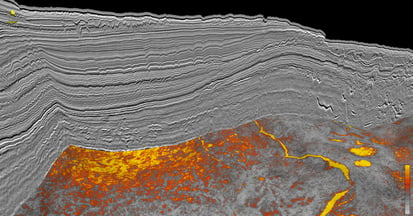
However, things have dramatically changed in this region over the last few years. TGS now offers over 59,000 km2 of regionally consistent high-quality 3D coverage in an area . This modern seismic (acquired since 2017) in these two basins. Our data indicates new sand fairways, new pre-Cretaceous highs, and 50-60 commercial-sized gas or oil leads and has opened up new under-explored plays in shallow (Miocene-Pliocene) and deeper target intervals where sill intrusions and basalt have previously been a challenge. 


Crucially, TGS seismic has been unable to unveil the prospects hidden by complex basalt rock. Through exclusive seismic imaging algorithms such as dynamic matching full waveform inversion (DM FWI) and Common Offset Reverse Time Migration algorithms, subsurface velocities can be interpreted separately with extremely high confidence and in greater detail. Specific features such as terrains of rotated fault blocks can now be identified beneath the basalts. The seismic velocities below basalt are slow, indicating well-preserved sediments under various thicknesses of volcanic rock.

Why Norway? Why Now?

  • Modern subsurface data has the complexity, high-end technology, and modeling potential to unlock prospectivity, especially within the basalt.
  • The playground (source, reservoir, seal) is in the right place for low-cost exploration.
  • An under-explored area the size of the N. Sea. The only area of such magnitude that is still unexplored.
  • Cross border understanding is better than ever. Data ties to a vast well library offshore Shetland.
  • Increased confidence in the sands is bringing back major players to the area.
  • Volcanics are beginning to indicate positive prospectivity potential.

Data Availability

VIEW IN INTERACTIVE MAP


3D Seismic, Marine Gravity and Magnetics

  • Atlantic Margin 2020 3D - 8,782 sq km
  • Atlantic Margin North 3D - 15,520 sq km
  • Atlantic Margin North 3D Phase 2 - 6,789 sq km
  • Atlantic Margin South 3D - 31,420 sq km

New Subsurface Insight Reveals Prospectivity

TGS has led the way in exploration along the Atlantic Margin from the western Barents Sea in the north to the areas West of Shetland in the south. The Møre and Vøring basins are challenging seismic terrains that include soft sediment deformation in the overburden, shallow gas, seafloor slides, and where volcanic sill complexes intruded Cretaceous basin and sub-basalt targets within the Møre and Vøring marginal highs. Since 2017, TGS has acquired more than 59,000 km2 of high-quality 3D data to provide a new understanding of the volcanic complexes in the outer Møre Basin, the sediment-basalt interaction, and the distribution of sand systems.  Several prospective targets, that previously have been covered by poor quality vintage 3D data or lacked data altogether, can now be interpreted in detail and support new exploration wells.


This project covers a region that is immature with regard to exploration drilling, although it is close to existing infrastructure and the market. The technical drilling successes in the region so far have found oil and gas in Upper Cretaceous and Palaeocene units. The Ellida and Havsule wells indicate that an active oil source is present in the Møre Basin, but the common expectation is gas. The Ormen Lange field, discovered in 1997, exports gas equivalent to 20% of the natural gas consumption of the UK market.

TGS is at the forefront of developing new techniques to better image the volcanic and intra- and sub-basalt targets through our Sub-basalt Imaging Research (SIR) project and AM20 Laboratory. This enables the data to image both shallow gas targets and image below the volcanic facies and the deeper Jurassic pre-rift structures. New play concepts and ideas regarding prospectivity continue to open up new opportunities.

Subsurface visualization from the Atlantic Margin North survey showing significant amplitude anomalies at the Top Lysing level

Unique, detailed velocity models using Dynamic Matching FWI reveal intra- and sub-basalt structures.

New insight gained through the Atlantic Margin data suggests why previous drilling may have been unsuccessful

Utsira Article 2 THUMB

Technical Article: AI and Ultralong Offsets Updating the Story of Utsira OBN

Earth Science Analytics and TGS have combined the power of machine learning and historical data with the modern Utsira OBN survey. Read the full article here