


Why Mozambique?
The abundance of resources offshore Mozambique will offer potential partners an opportunity to fast-track Africa's energy transformation.
After several major gas discoveries made offshore Tanzania and northern Mozambique, the entire East Africa margin has been assumed to be a gas province. However, some believe that there is evidence for a new oil province along this margin based on an interpretation of seismic data - a whole different prospect for this fascinating region.
Our Data Coverage
Our Data
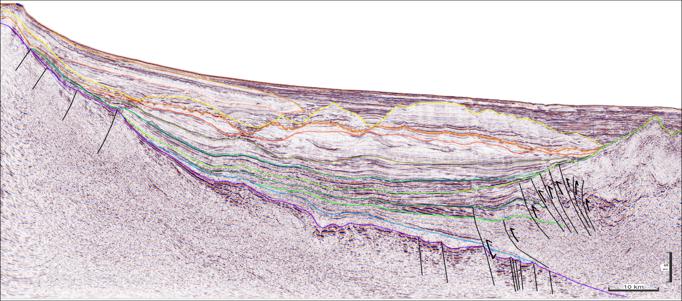
TGS has 19,772 km of long-offset Broadband 2D MultiClient seismic data available offshore Mozambique. This seismic dataset images the subsurface potential in open areas of the southern Rovuma Basin and the western flanks of the Kerimbas Graben, revealing the prospectivity in this region for the first time. Potential targets include Cretaceous and Tertiary structural and stratigraphic plays.
The survey also images the syn-rift structures and Late Cretaceous pro-delta stacked mixed system sequences in the northeast Zambezi Depression. The area has much lower geothermal gradients than the northern Rovuma Basin, and source rocks are shallower, so this area, rich in oil slicks, is an oil play.

Mozambique Prospectivity
The Mozambique Channel covers an area of approximately 170,000 km2, extending between the Zambezi Delta in the south and the Rovuma Basin in the north. The Jurassic rifting and the separation of the Gondwana transitioned to drift and tectonic quiescence through the Cretaceous during the opening of the Indian Ocean. Davie Ridge transform structures dominate the north of the Angoche Basin, with a north-to-south orientation.
Reservoir targets are interpreted as Tertiary and Cretaceous turbidite and contourite clastic deposits, similar in nature to those in the Rovuma basin.
Trap systems include stratigraphic pinch-outs and occasional structural traps.
Source rock is proven but undrilled offshore Mozambique. Numerous source rock intervals have been identified on seismic through the Jurassic and Cretaceous and are expected to charge the Cretaceous and Tertiary reservoirs. This hypothesis is corroborated by comparison with conjugate margins, analogues, and by studies carried out on oil slicks observed on satellite images.
Click on image to view data example
Speak to a Specialist
Interested in a product demo or trial? Let us know your needs and we’ll connect you to the right person or team.
Book a Data Viewing
Want to see the latest seismic data solutions and imaging technologies in your region of interest or for the next license round? Book a data viewing with one of our experts.
Discuss Your Seismic Data Needs
Every need is different and we'd like the opportunity to discuss yours further. Speak to one of our data or geoscience experts to customize seismic solutions specific to your requirements.